Hedley October 8

A bit smokey on Hedley lauch!

 On my way back to Vancouver from southern Utah, I stopped at Hedley as the local South OK group was flying there.  It's been years since I flew Hedley and it's still a bit of a scary place to fly if there is wind forecast.  Fortunately even though there was a morning wind, it died shortly after we got up to launch.  However the smokey skies did not dissipate (there was a fire in nearby Keremeos) so not much of a view.

Rob doing some week-whacking while we parawaited.

Spent about 45 minutes below launch height, scratching against the rocks to the west.  A few other pilots held on as well, but turned out to be a bit more stable than we would have liked, ah well good to fly the site again!


The Similkameen River at the Rustic LZ has a pool to cool off in!


5-week road trip to southern Utah

After attending last year's Red Rocks fly-in and having a fantastic time, I've been wanting to go again and enjoy the sand, heat, and dryness (compared to Vancouver!).  This year there was a trifecta of events going on in September: the Red Rocks US Nationals, the Red Rocks Fly-In, and the X-Red-Rocks, so there were going to be lots of pilots around the area for over a month!

The fall colors in full swing!


Southern Utah is a gem of a place to visit and especially in the Monroe/Richfield area, due to the multiple paragliding sites, some great hotspringing, and oodles of National Parks within a day's drive.  July and August tend to be thunderstormy due to the numerous Gulf of Mexico monsoons throwing bands of precipitation into Arizona and Utah, whereas by September the monsoons have largely finished for the year.  As well it's cooled off a bit and the crowds are less!


First off was the final leg of the US PG Nationals.  The weather was not the greatest as there was a late-season monsoon swirling in the Gulf of Mexico, throwing bands of storms at us, but we were able to get 3 tasks in.  I think the comp was just held a bit too early, a week later, with an extra buffer week to allow any late-monsoons to dissipate and the weather to normalize, would have been ideal.  Results can be found at the Air Tribune website.


Alex tries out a new stump-clearing technique during a parawaiting session

The Red Rocks Fly-In is pretty much the largest free-flying event in the USA, up to 300 pilots will participate and the logistics are to the point that it's a well-oiled machine!  There are 3-4 flying sites close to Monroe, 2-3x daily shuttle service, a large LZ with bathrooms, grass, shade, and running water, cheap or free camping nearby, and lots of other activities to do if you want to the take off from flying.  Rather than re-list all the amenities, simply visit my last year's post since most of the info remains current.

Red Rocks 2021 Blog Post.

Meadow Hot Springs and the 30' deep pool.

This year the RR Fly-in was sold-out, but fortunately with the multiple flying sites and huge skies, it's hard to say things are crowded...The new challenge this year was hiking up the training hill (300', 10 minutes) and seeing if you could bench up and away to Monroe Peak behind you.  On an overdeveloping or potentially windy day when you aren't sure you want to be up high, this is an excellent option!


Sunset at the north rim of the Grand Canyon


Once again, flying in Monroe in mid-late September was very picturesque as the larch trees are just changing colors from green to gold, the maples are going red, and there may be the odd snowfall to coat everything in white.  Simply spectacular, I never got tired of looking at the colors and the overall vistas.

Climbing out over the Junction launch.


In addition to the flying, I took the opportunity to visit many of the nearby National Parks.  There are 5 within a few hours drive of Monroe (Arches, Bryce, Zion, Capitol Reef, Canyonlands), and if you are willing to do an overnight drive, you can go see the Grand Canyon too.  And going in September is *much* nicer vs. July or August...less or no crowds and the temperatures are more reasonable.  One thing I really enjoyed, overnighting in the Parks, is the fact that many are "International Dark Sky"-rated, which means they are exposed to little to no light pollution and thus you can make out many celestial features that are otherwise obscured by nearby city lights.  Camping out under an easy-to-see Milky Way is an experience I urge everyone to do at least once.

One of the many sights in Arches NP.

Hot springing is easy to do in southern Utah.  Monroe boasts some commercial hotsprings, but if you want the "locals' experience", go to Red Hill Hot Springs (Google it).  And if you want to see some really special hotsprings with swimming and diving, check out Meadow Hot Springs near Meadow.  And finally, if you want to go further abroad, check out Fifth Water Hot Springs just east of Spanish Fork.  These ones are a ~45 minute hike in and rather than only a couple of pools, the entire river at the 45-minute mark is hot, just pick a random spot or sit under a hot waterfall!  Go early in the morning (I went at 7am) and plan to be out by 10-11am as the daily crowds arrive.  If you go early enough, you'll have the place to yourself for an hour or so!


Several of the established pools at Fifth Water Hot Springs. 
You can also just pick a random spot if the pools are too crowded for your liking;
the entire river is hot at this point!


After nearly 5 weeks in southern Utah and the fall XC season winding down, it was time to head back to Vancouver.  But one more stop, Yellowstone National Park is (almost) on the way back!  And with it being early October by this point, the crowds were minimal and in fact some amenities were closed for the season, and overnight frost was common.  This park is a geologists dream with steaming hillsides, geysers, and hot acidic pools.  Oh yeah, wildlife is all over the place too!

One of the many hot acidic pools at Yellowstone NP.


I'd say my favorite part of the park was the boardwalk surrounding the main geyser area.  From the boardwalk you can safely walk within a few meters of steaming fumaroles and venting geysers, and you can see the footprints of the local wildlife that all of a sudden stop and there's a new hole where the ground gave way...don't leave the boardwalk!  Be aware of the crowds that will surround Old Faithful, there is a clock there that will give you an idea of when the next eruption is scheduled so you can plan things in advance.  If you want a less-crowded eruption-viewing experience, walk the boardwalk to the other side and you'll see the eruption from another angle and away from the amphitheater.  

Part of Grand Prismatic Pool.  The rest of the pool is hidden in the steam. 
There is actually an overlook view of the entire pool from the hillside behind.

If visiting Yellowstone NP, I would recommend planning your overnight stops in advance since things tend to book up, and with the size of the park there's no way you can see it in a day...you can spend 2+ hours simply driving from one part of the park to another.  Add in any hiking or exploring off the beaten path, and you are looking at 3-4 days easy.  Also bring enough days of food and water...there are limited shopping and restaurant opportunities once inside the park.


Lower and Upper Bridal Falls August 14, 2022

Waiting for the knob traffic jam to dissipate before launching.  Photo courtesy of Alex Raymont.


A nice, rather average, but totally flyable day, at Bridal.  With the Woodside shuttle out of service, and the cancelled Sunpeaks fly-in pilots on their way back to the coast and the Island, Bridal was busy!


Launched and got away from the knob traffic jam and then flew up to Upper launch and top landed.  Nice and quiet up there, lots of berries on launch!  Alex also top landed and then relaunched to fly to Cheam, while others flew to Ludwig and Elk.  All in all an uneventful day in the Fraser Valley and lots of happy pilots at the Wildcat for dinner later that evening!

Lower Bridal Falls August 5, 2022


The forecast was calling for east and northeast wind in the Fraser Valley, which will often produce thermals going high enough to get over the peak of Cheam.  This happens maybe a half-dozen times a year, so when you see a forecast such as this, you go!

Windgram for Bridal for August 5.  Notice the NE wind up high, conducive to Cheam altitudes!

There was quite the crowd at launch and with the east wind, pretty much everyone was launching from the top launch.  Once in the air it was very much east wind, so much so that I went east to find my first thermal...not west like on "regular" days.


The east wind was somewhat significant, so we had to be careful not to get in the lee of the flanks of Cheam.  These flanks are usually a washing machine on the best of days, so on a day such as this, even more so.  I actually ended up trying 2 times, and going out towards the highway, before I found a thermal strong enough to get me high enough to get around the SW flanks of Cheam with little drama.

Looking at the NE face of Cheam, we often don't get to thermal up that side very often!

Once over on the north side, things started looking up.  It was almost ridge soarable on the north side and I was able to smoothly climb up on the pyramid, which is usually in the lee of the typical inflow SW wind, and not a good place to be on regular days.  But today was not a regular day!  We were all getting up on the N and NE side of Cheam, it was smooth thermals, and clouds were forming at 2200+m!


Paddy, Alex, and I climbed up on the NE side and over the summit where there were many hikers waving and taking photos.  Soon thereafter a half dozen additional pilots thermalled up, and we had quite the crowd in the air over the summit of Cheam in the smooth air.  It was 6pm and the hiking crowd still had a 2-3-hour hike/drive down ahead of them before dark, while we could be on the ground and next to our cars in under 30 minutes if we wanted!  But we didn't want to...it was too awesome to want to leave so early.


But I don't think anybody had dressed for freezing temperatures...it was something like 5ºC at cloud base, and we were dressed for 25ºC.  Lots of comments about freezing hands etc so it was time to land and talk about how awesome it was to thermal up the NE side of Cheam.  Rare to get an over-Cheam day, even rarer to do it on the NE side!


Lower Bridal to Cheam summit flight.


Mt. 7 July 27, 2022

 The previous day I had chased for Guillaume and Alex who flew to Fort Steele and Jaffray (200-240km), today was a fly day for me.  Lots of pilots in Golden for the Willi Muller XC Challenge, plus the BCXC group was in town, so launch was a bit busy!

Mt. 7 Windgram for July 27

Launched and was able to get above launch right away which started the lemming-effect on launch, glad I was in the air by then!  I found the air was not very pleasant and had a lot of north in it, and with all the ridges on Mt. 7 that creates lots of lee spots.  I spent a lot of time trying to get high, and eventually my persistence paid off with a thermal to 3900+ m right over the peak of Mt. 7 (CYA167 goes to FL250!).


With that kind of altitude I was able to skip the whole Pagliaro business and get straight to Bicarbonate peak, and then it was the usual fight to stay high, but not so high that you were busting airspace (in that area @ 3810m).  Pilots were busting airspace all over the place as cloud base was somewhere near 4200+m, and going deep whenever the opportunity presented itself.  I was finding the air bouncy and rough (typical Golden!) and did not want to go deep at the range split, as I've seen what that can do to pilots who get low and now need to make their way out in the lower-down wind, or toss their reserve back there and end up with an epic walkout or heli-rescue required.


We are allowed quite high at Mt. 7, but once south, our allowed airspace lowers.

Was working my way along the Brisco/Spur Valley section when we heard that Guillaume had tossed his reserve near the Judge peak and Diana Lake, had a long reserve ride down (enough time to stuff his glider in his pod!), and crashed through the trees, not catching, and hitting the ground.  He was complaining of a sore back and was walking out to the Diana Lake lodge where there were staff and guests, but was asking me and Alex, via his DeLorme, to arrange a retrieve from the Diana Lake trailhead.


While all this was going on I was getting tossed around as I was approaching Radium, and the rocks were getting uncomfortably close, and my spidey senses were going off, so I opted to head out and landed in Radium, while Alex landed in Invermere.  I was able to thumb a ride back to Nicholson right away (the second car that came by stopped for me!), and when Alex returned he was able to arrange a truck to the trailhead to pick Guillaume up.


95km flight to Radium.


Overflying Kapristo peak, cloud base somewhere around 4200+m.  Photo courtesy of Alex Raymont.


Guillaume was checked out and nothing broken, just bruised, and a few days later his gear was retrieved from where he had stashed it for the original hike out.


Even after flying there for 20+ years, I still fly out and land if things are getting too rowdy for my comfort level.  If planning to fly Golden, please have a satellite tracking device so others can find you, as there will often be zero cell service and your radio will only transmit so far.  In this case Guillaume was able to let us know via his radio, and subsequently via his satellite tracker,  that he was OK and his self-rescue plans, which meant there was no need to involve Golden Search and Rescue.  Golden SAR was actually used a few days later for another pilot who had tossed near Parson, gotten caught up on a cliff during his descent, and required SAR to extract him from the cliff while he had pelvic injuries.  Golden is a big air, strong, turbulent, prone to wind, and demands respect!  

Upper MacKenzie Pemberton July 2, 2022


Windgram for July 2 @ MacKenzie launch

It was a great-looking day but I found the climbs and air a bit rough, and not much fun.  Completely doable to do the Spindrift-and-return run, but I wasn't in the mood to get beat up on the run, so turned around at Goat Mountain.  After returning to launch I crossed over to Satellite peak and found the air much nicer over there, and had a great time boating around over the Rutherford valley and the Miller drainage and watching the pilots coming back from Whistler *way* low.


68km OR flight.


Upper MacKenzie Pemberton to Lilloet, June 25, 2022

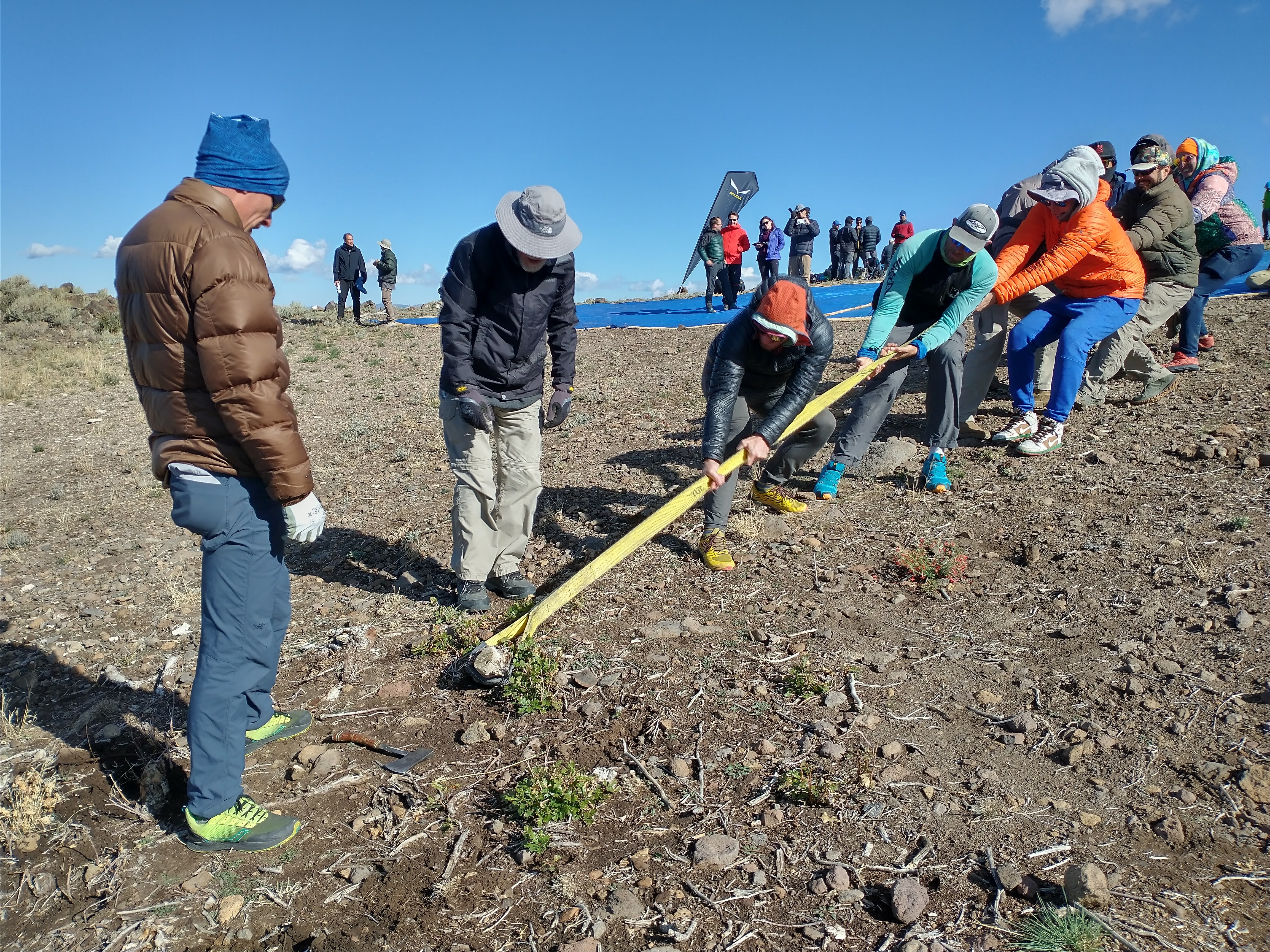
 June 25 was one of those rare "red alert" days, where the weather lined up (light winds, high base) coupled with the fact that it was a weekend (= lots of retrieve options via the public) and it was late June (= lots of daylight hours to go XC).  In fact the longest day of the year had only been a few days before!


Weirdly enough, a lot of the "top guns" who would have been salivating at such a day were otherwise occupied...finishing up at Chelan comp #1, on their way down to Chelan comp #2, or traveling in Europe.


I had noticed the upcoming conditions the day before and had made a tentative plan to fly to Lilloet via the Duffy Lake Road, and even onwards to Cache Creek if the day allowed.  I announced my intention to some pilots at launch and had some interest, although there were other pilots interesting in flying to Whistler, to Squamish, or to Gold Bridge.  But I had a few people interested in coming along.


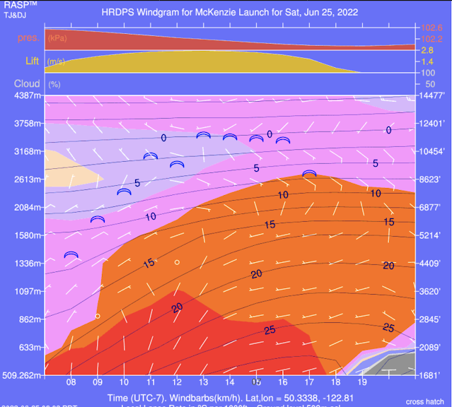
Light winds, high base, what's not to like?


Launched early, before noon, and was able to get up on the SE side near the towers.  It was a pretty easy climb out and I could see nice cu's forming and no overdevelopment in the Kamloops area or the Chilcotin (yay!).  However there was a rather unwanted east wind, and we were only getting to 2700 m or so, which made the idea of flying to the Duffy Lake road a bit less interesting.


We were a gaggle of 6 pilots, milling around behind launch, when, after some radio chatter about what to do, we opted to fly down the Anderson Valley to D'Arcy, since that was the alternate route to Lilloet as well as an alternate route to Gold Bridge and Bralorne.  Now, we don't often fly this valley for 2 reasons:

1. It's a narrow windy valley.

2.  It's full of power lines.


Neither feature make it an enjoyable valley to fly in regularly, but with the light winds, the fact we weren't planning to come back via the same valley, the fact cloudbase was supposed to get higher (the prediction was 3500+ m), and the fact we actually had a gaggle (= safety in numbers) to help with the transitions and finding lift, made flying this valley possible.


Once you get to Birkenhead Mountain, you actually get the odd "safe" LZ, but I was feeling good and staying high, and I knew from previous trips to Birkenhead Provincial Park that up ahead were really nice LZ's (off the main road, but on the way to the Park, which on a weekend would have lots of cars going in and out, so lots of retrieve options).  The clouds were still behaving, cloud base was getting a bit higher (I was getting to 3100m at Birkenhead Mountain), and I could see the route to Lilloet was looking good from a sky point of view.


From a LZ point of view: not so much!  After D'Arcy, you pretty much lose all LZs, and Anderson and Seton Lake have no LZ's and the surrounding mountains just drop right into the water.  There is a railway along the west side of both lakes, and in a real emergency, you could *maybe* put it down on the tracks (fortunately the train is very infrequent), but then you'd be faced with a multiple hour walk out along the tracks, either backtracking to D'Arcy or continuing to Seton Portage or Lilloet, depending on where you ended up on the tracks.  But it was the weekend (!) and there were oodles of boats on Anderson Lake.  I figured if I ended up on the tracks, I could probably get a boater's attention and then get a boat ride back to civilization.


The first jump to the north from D'Arcy was the scariest with leaving the safety of the LZs as well as losing a good chunk of my gaggle...we ended up splitting in half with the others saying they were going to fly to Gold Bridge, and those sticking with me (Chloe, Kiwi Tom, and Lorne) had never flown to Lilloet either.  So it was the blind leading the blind.  But after the first couple of jumps I was getting more comfortable and the skies were still looking great (we were getting to 3300m by now), and we were staying so high that the lack of LZs was more of "background noise" than a full-on concern.


The east wind we had experienced back at launch had never gone away, so even though the west side of Anderson Lake (facing east) was not the "standard" side to fly along, the east wind meant the thermals were actually flowing up that side of the terrain, the train tracks are beneath you (rather across the lake if you were flying the other side), and the fact it was near the longest day of the year meant the east-facing slopes were still in sun and working just fine.  I believe a lot of the other flights along this route are on the other side of Anderson Lake since that side faces west.


Up ahead I could see the land bridge that separates Anderson Lake and Seton Lake, with the community of Seton Portage nestled inside it.  I've never actually been to Seton Portage, so had no idea what there were for LZs, but it looks like (from the air) that there are a couple of fields you could land in.  The road in is over the mountain Pass from Carpenter Lake, so it's not an easy-accessible community, so the traffic in-and-out would be minimal, but again, with the weekend, I figured there would be some traffic out to get a ride if needed.

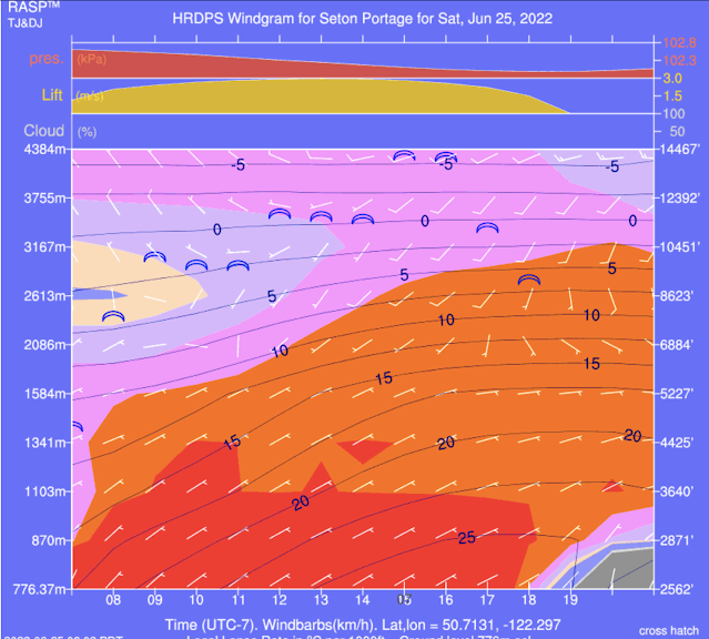
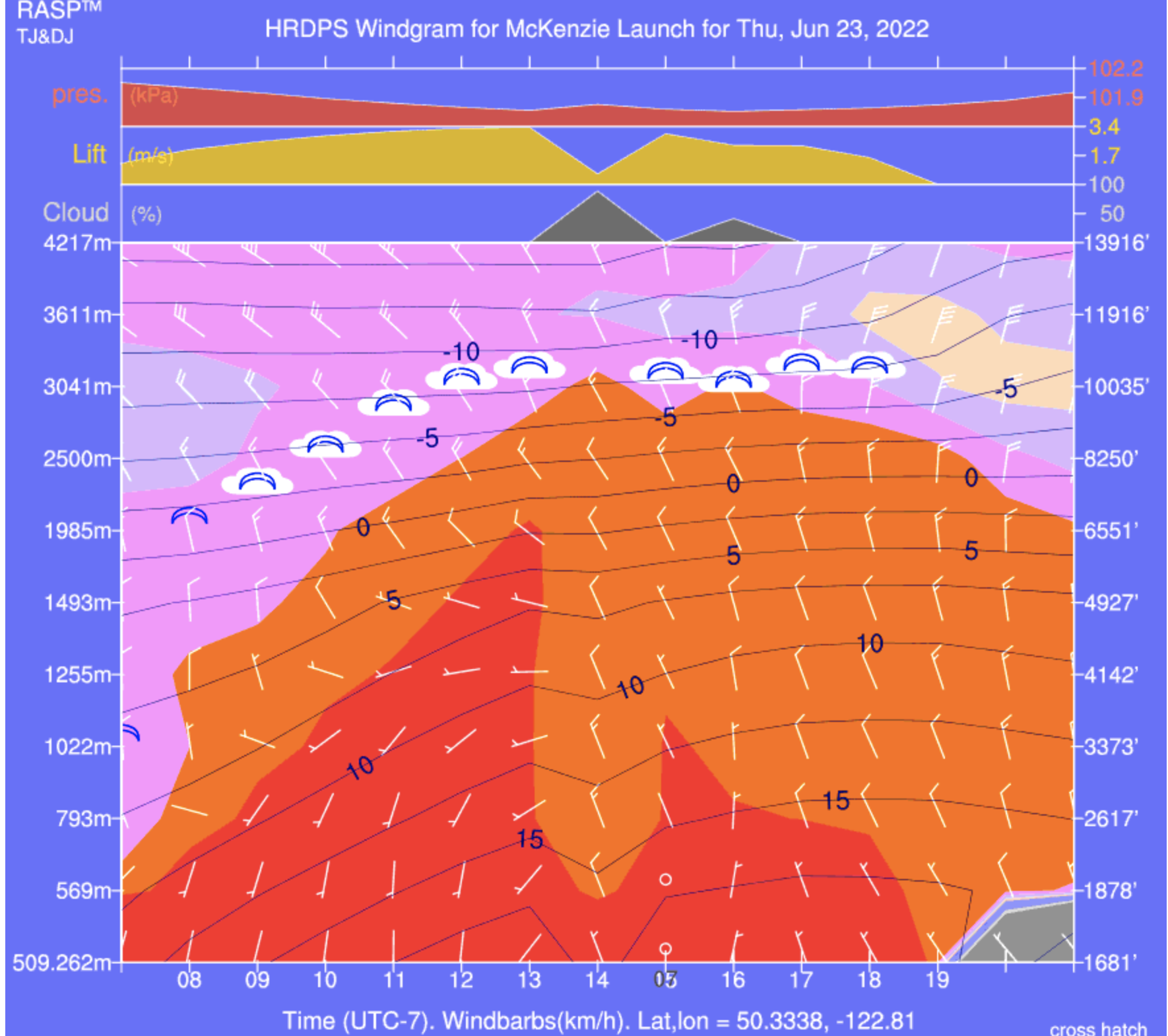
Seton Portage RASP...still light winds!

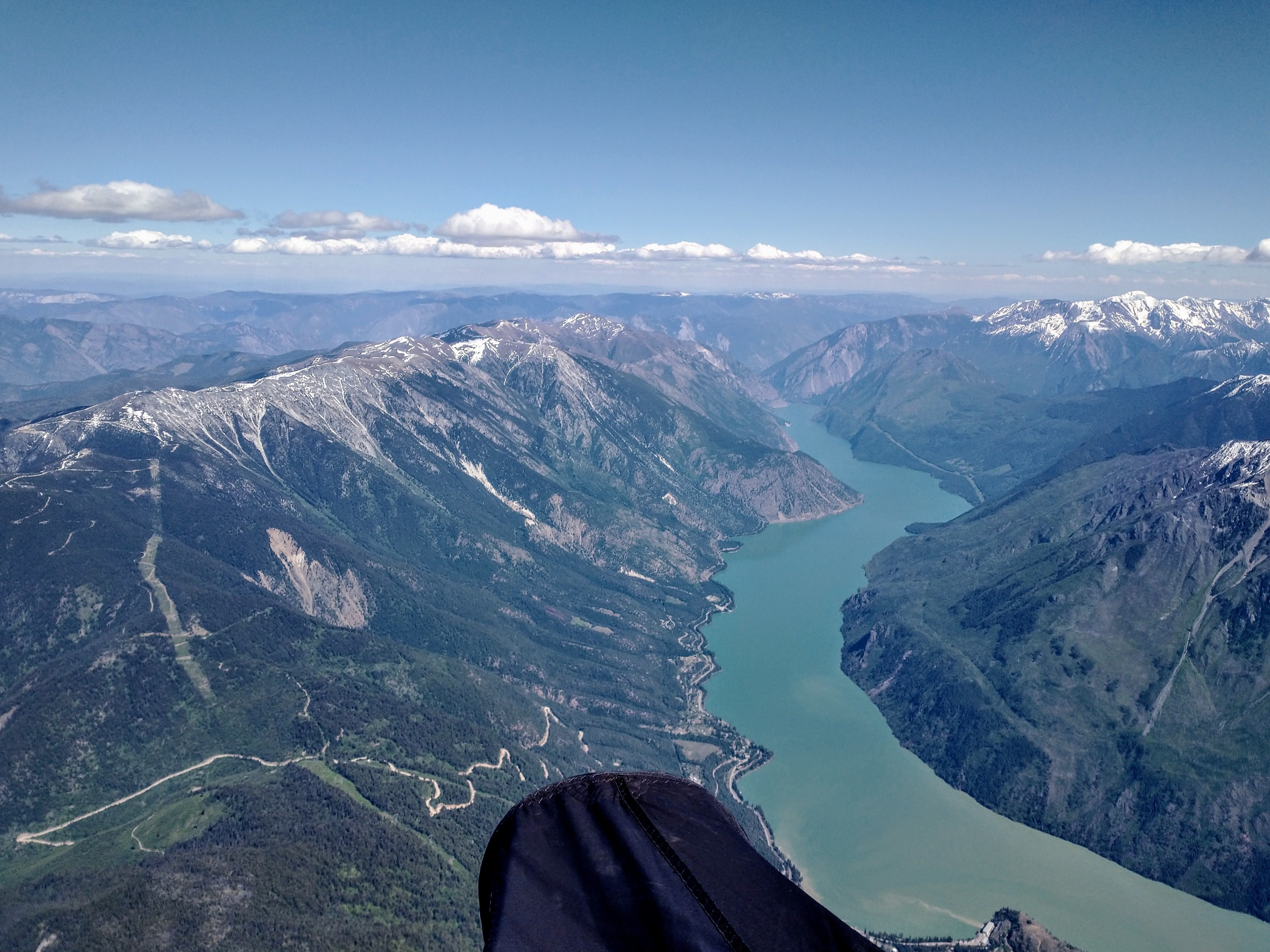
However we were staying high (cloud base was by not 3500m) and I could see all 3 lakes from my viewpoint: Carpenter Lake with brown water (its water level was very low...you could actually land all along its shoreline right now), Anderson Lake with blue water, and Seton Lake with glacier-green water.  Plus I could now see the Moha valley with all its fields, and the terrain in general was becoming more dry and less treed, good from a landing point of view!


Once past Seton Portage things were just excellent...a nice high cloud street, a light east wind, and I could see the beginnings of Lilloet and the safety of civilization and LZs.  The only thing that would have made things nicer would have been a light SW wind...as it was we had been fighting an easterly cross-wind for most of the flight which made "downwind" not really a thing and thus slower-than-usual groundspeeds for an open distance flight.  But hey: flying to Lilloet, shouldn't complain!


Flying over Seton Lake.  Seton Portage is directly under me.  You can see the FSR dropping into SP just past my pod.


As we dropped into Lilloet Lorne was asking what my intentions were.  It was only 5pm, continuing to Cache Creek was a possibility, so I decided to see what would happen on the crossing to the cliffs behind the Lilloet airport...it's a long crossing.  Somewhere along the way we had lost Kiwi Tom, but he had turned around shortly after D'Arcy and returned to Pemberton as he needed to be back in town that night and couldn't risk the possibly-long-retrieve.  So it was just myself, Chloe, and Lorne.


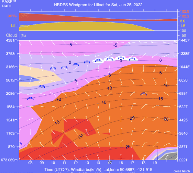
Lilloet RASP...light winds which is very rare!


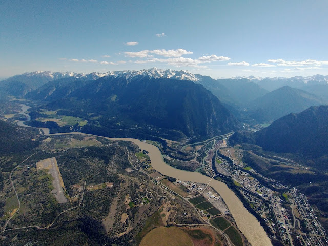
Crossing Lilloet to the airport cliffs was a long glide, and with the lack of west wind it was slower than a usual downwind crossing would be.  I could see a nice cloud street continuing to Marble Canyon, but after that it was blue, no cloud streets, and meanwhile Lorne was saying we had a retrieve arranged if we landed in Lilloet.  That, coupled with the lack of a cloudstreet past Marble Canyon, the possibility of landing in between Marble Canyon and Cache Creek, and the fact we had just had a fantastically scenic flight over some unlandable terrain made me think "Yeah I'll stop now".  So rather than continuing into the blue, I switched modes to "tourist mode" and hung out over the cliffs at the airport, enjoying the view of the Fraser Canyon which we often don't get to see via paraglider!


BTW, Lilloet airport is an uncontrolled airport (like the Pemberton one) so we can land there.  There was little air traffic that I could see but with the fact it was a weekend and a likely time for recreational GA pilots to be going in and out, I decided landing closer to the main road and away from the runway would be the better option.  I could see a nice empty field at the T-intersection at the bridge over the Fraser River, but just as I was setting up my final approach a herd of horses popped out from the small building at one corner and started milling about the field.  Sooo, quickly popped over to my backup LZ (I try to always have a couple of backup options just for cases like this) and landed in the waist-high spearhead grass in zero wind.

Coming in over Lilloet and the Fraser Canyon.


Now for those of you who don't know, spearhead grass is the bane of clothing and shoes.  It sticks to everything and has a barb, so will not come out without a lot of work.  The few times I've landed in spearhead grass fields, I usually have to throw away my socks as they are pretty much unusable by that point (or spend hours pulling them out manually).  So after Lorne and I packed up we were walking out with sharp pokes with every step.  That's why I usually avoid speargrass fields if possible, but hey, as a backup LZ, they'll work in a pinch, and of course are not farmed so you don't have to worry about crops.


Lorne had called his friend in Lilloet so our ride was more-or-less ready for us when we reached the highway, so it was just a matter of finding Chloe.  Turns out she had landed on the other side of the river (her radio was not working so couldn't hear what we were doing for landings) so we were able to find her next to the gas station just at the entrance to the Duffy Lake road back to Pemberton.

Looking back at Lilloet from over the airport.  You can see the tip of Seton Lake where we came from.

All collected, we were back in Pemberton in about 2 hours, and before dark!  Many thanks to Lorne for arranging the retrieve!  Otherwise we would have been hitchhiking which usually adds a couple more hours to the whole retrieve, or gotten a hotel in Lilloet and retrieved the following day.


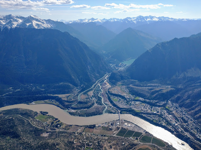
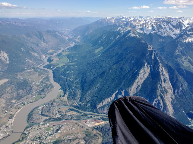
Looking over Lilloet and the 2 possible routes in from Pemberton.  Our route via Seton Lake on the right, the alternate route via the Duffy Lake road on the left.

While it was not a long flight (the straight line distance is only ~100 km), it was a very technical flight and over terrain that is pretty unforgiving.  A typical day in Pemberton you can't (or shouldn't) do the flight due to valley winds at both the beginning and ending of the flight...Lilloet is notorious for afternoon winds.  After having done the flight via the Anderson/Seton route, I must admit I think it may be safer vs the Duffy Lake Road route.  At least along 2 lakes you have the possibility of landing on the train tracks....along the Duffy there are only a handful of LZs and most of them are on the Pemberton end of things.  Once you get past the highpoint of the Pass, it's pretty much a canyon all the way to Lilloet and the only places to safely land at that point are up high.  I'm so glad I did the flight as the scenery is outstanding and I don't often do open distance flights due to the retrieve issue.  But once in a while it's good to get outside your comfort zone!


98km open distance flight to Lilloet.


Upper MacKenzie Pemberton, June 23, 2022

RASP for June 23.  You can see the overdevelopment spikes for the afternoon.


Light north aloft, which usually means it'll be a bit rough and bumpy, at least on the MacKenzie side.  This time was no different!  It was also rather on the unstable side, so in the Interior, down Lilloet Lake, etc, it was overdeveloping, so it wasn't going to be a big distance flight.  Plus it was COLD, like, -10°C at top of lift cold!

Sooo much snow still!  The Copperdome bivy site is still covered in snow, which means an easy toplanding and lots of snowmelt available for drinking, but you'd need to bring your winter camping gear to sleep on the snow.  But also with that much snow still, no mosquitos!

As predicted, the MacKenzie side was kinda rough, so after returning to launch I jumped over to the Miller side and Satellite mountain where the air was *much* nicer.  Fortunately because it's the height of summer, the east-facing slopes are in the sun for most of the day, so being on the Miller side in the afternoon still had plenty of thermic action.  Popped my head into the Rutherford Valley just to see what was going on, yep some OD to the south now down towards Whistler-way, time to go and land!


56km OR flight
.

Nova Scotia, May 31-June 13, 2022

 We had been unable to get to the Maritimes for the past 2+ years due to them having a "Covid Bubble" whereby non-residents were not allowed to enter.  But with the dropping of that restriction it was time to visit the parents and also do some Nova Scotia exploring!  Plus, with the predicted "June-uary" weather for Vancouver, Nova Scotia is actually the better destination for springtime sun!

Inverness just north of the golf course, Cape Breton.  
Launch coordinates which is off the green and public property...do not launch on the golf greens!

Nova Scotia weather is much more changeable vs. Vancouver.  Often it'll be sunny for a few hours then cloud over (or vice versa), hard rain, wind, etc, followed by more sun.  So if you don't like the weather, wait a few hours!  When we arrived we were just getting into a period of north wind, which means any flying to be had would be on the Noel Shore on the south shore of the Bay of Fundy.  (There is also a NW site at the Joggins Fossil cliffs, but that is a further drive.)


Inverness at the golf course, Cape Breton

For those who are unaware, the Bay of Fundy has the world's highest tides so when flying the Fundy coast, you need to know where the tide is, and whether it's coming in or going out.  It'll change up to 50 feet in 6 hours, which translates to ~8 feet per hour.  If you land when the tide is coming in, you may need to run to stay dry!  Get your tide information at the Bay of Fundy Tourism website.

Cabot Trail, Cape Breton

Kiting up from the beach at West Mabou Beach Provincial Park.  Launch coordinates.

The winds were a bit burly during our Noel Shore excursion, so we actually didn't fly, but we found lots of sites!  The great thing about Nova Scotia flying is that the people there are super friendly, and will welcome you onto their beachfront/cliffside/bluffside properties to fly from their backyards.  As well, Google Maps on satellite view and Street View is a great resource...simply find a potential cliff/bluff site, and look to see if there is a row of trees along the edge.  If not and it looks like grass to the edge, it's likely launchable, just look at other things like undercutting cliffs, is there beach below, how to get back up if you beach land, etc.


Havre Boucher, near the causeway to Cape Breton.  This will work in a north wind.
Launch coordinates...access this via the beach and be discreet!


Sunset at our "Glamping off the Beaton Path" campsite near Inverness.  Highly recommend you stay here for at least 1 night!

One thing that is useful to know about flying relatively unknown beach sites, is that you *don't* have to launch from the top.  Often times you an inflate on the beach, and kite your glider up into the lift band, either by walking it into a Venturi area (just make sure you don't get sucked in behind!) or climbing up the bank a bit until the glider bites into the air.  This is quite useful when it's a bit too strong to launch from the top, the top has too many bushes etc, or you have landed on the beach, want to relaunch, but don't want to hike all the way back up.  This works best on smaller bluffs which have an angled face you can climb up on, or a bluff with a low spot/dip/venturi to use.


Havre Boucher, near the causeway to Cape Breton

One other thing we wanted to do was drive the Cabot Trail (a famous scenic drive in Cape Breton) through the Cape Breton Highlands and also do some flying at the various sites.  Protip: drive the Cabot Trail counterclockwise, so you get the cliff views from the proper side of the road!

Flower Pot Rock (coordinates), near Bramber on the Noel Shore

The west side of Cape Breton is a goldmine for flying, there are simply few pilots that live nearby, so most of the sites are unflown.  You will find the best sites anywhere from  in the north, to Inverness, to Mabou in the south.  All these sites will take some form of westerly, and depending on the angle of the coastline, it'll be SW or W or NW.  You do not have to worry about the tides quite so much in Cape Breton, so if you see beach, it'll be that amount of beach more or less all of the time.

Flower Pot Rock

Bramber Beach

Once again, Google Maps satellite view, and Google Maps Street View, are your friends to find a suitable launch site.  There are several "established" sites, most notable in Inverness @ Broad Cove, and the Mabou cliffs, but often you will just have to find a site that works for that day's wind direction by Map searching.

Lawrencetown Beach Tea House, near Halifax.  Launch coordinates.

Back on the mainland, there are a couple of flying sites near the Halifax area.  The most commonly flown one is Lawrencetown Beach, with a flying site at the Tea House/Surf Shop, and another flying site a few km's down the road at Half Island.  Both sites take a SW, and there is beach to land at.  There is another site at Hirtles Beach, near Lunenburg, also takes a SW (SSW is better), just follow the public path up the bluff and find a spot which is not too covered with wild roses to lay out.

Flying at Half Island near Lawrencetown Beach.


Lawrencetown Beach Tea House


Half Island Beach.  Launch coordinates.


Half Island.  West launch is just outside the FOV on the left, south launch is in the distance.

Half Island from the south launch.  

Finally, the most flying in Nova Scotia takes place in the Parrsoboro area.  There used to be a school, but is has since shut down, so the flying is now less, but the sites remain!  There are various sites for SW, S, SE, and E.  And once again, be aware of the Bay of Fundy's tides and the fact the beach LZ may disappear during your flight.

Flying south of Inverness (launch coordinates).  The famous golf course is in the distance!

In all these scenarios, please be aware that the winds can change quickly, and what was once a nice breeze can go too strong quickly and now you are being blown back etc.  Keep an eye on the ocean for increasing whitecaps, catspaws, streaking, and also your instrument to see if your groundspeeds are going down as the wind picks up.  And if the temperature is getting too hot, you may get the famous "heat bubble" in which the ground is too hot to allow the ocean wind to come ashore, so you can see the wind just offshore, but it will be calm or not windy on launch.  You can wait all day for the wind to get the final km or so, but it will not arrive and tease you all day!  So if the day is predicted to very hot, this phenomena has a good possibility of happening.

One of the many views from the Cabot Trail.

For a more complete listing of flying sites, go to the HPAAC website.  It is updated regularly so the contact numbers listed there will be current.


Bramber Beach at sunset.


Woodside April 17, 2022

One of the rare good spring days we've had so far this year!  Lots of pilots out as it was the weekend and it was high-ish and cold!


Pretty easy cruising over to Bear and then topped up to 1800m for the crossing over to the Butterfly.  The Bridal side seemed to working better vs. Woodside, at least the climbs felt better, but west of Upper launch I had trouble getting as high as I had been getting further east.  Tried getting high at Gloria for the crossing back to Woodside but that wasn't really working, so returned to Upper launch, that wasn't really working as well :(  


Oh well, back to Lower launch where it's reliable, got to 1700m, and went for the glide back to Woodside.  Unfortunately the west wind had arrived down low and I didn't get any lift on Hopyard or Cemetery Hills, nor the sandbars, so landed at Harvest West dike field.  Thank you Al for picking me up!


46km FAI triangle flight.


Lower MacKenzie Pemberton April 11, 2022

I was in Pemberton for 2 weeks to cat-sit, and had brought my glider.  April is really too early for Pemberton flying as there is still snow around, especially in the Whistler valley.  But after most of the 2 weeks in the rain and snow, we finally had a possible fly day!


It was a bit on the unstable side for big XC, and in any case it was too cold to want to be up there for too long...-20C or even colder at 3000m!  I could only handle the cold for 30 minutes or so, had to land as the air was a bit too dynamic and too north for my liking and I couldn't feel my hands!  I believe Guillaume and Corey flew to Whistler though!


Methinks it's a bit unstable!!