We had been unable to get to the Maritimes for the past 2+ years due to them having a "Covid Bubble" whereby non-residents were not allowed to enter. But with the dropping of that restriction it was time to visit the parents and also do some Nova Scotia exploring! Plus, with the predicted "June-uary" weather for Vancouver, Nova Scotia is actually the better destination for springtime sun!
 |
Inverness just north of the golf course, Cape Breton.
Launch coordinates which is off the green and public property...do not launch on the golf greens! |
Nova Scotia weather is much more changeable vs. Vancouver. Often it'll be sunny for a few hours then cloud over (or vice versa), hard rain, wind, etc, followed by more sun. So if you don't like the weather, wait a few hours! When we arrived we were just getting into a period of north wind, which means any flying to be had would be on the Noel Shore on the south shore of the Bay of Fundy. (There is also a NW site at the Joggins Fossil cliffs, but that is a further drive.)
 |
| Inverness at the golf course, Cape Breton |
For those who are unaware, the Bay of Fundy has the world's highest tides so when flying the Fundy coast, you need to know where the tide is, and whether it's coming in or going out. It'll change up to 50 feet in 6 hours, which translates to ~8 feet per hour. If you land when the tide is coming in, you may need to run to stay dry! Get your tide information at the Bay of Fundy Tourism website.
 |
| Cabot Trail, Cape Breton |
The winds were a bit burly during our Noel Shore excursion, so we actually didn't fly, but we found lots of sites! The great thing about Nova Scotia flying is that the people there are super friendly, and will welcome you onto their beachfront/cliffside/bluffside properties to fly from their backyards. As well, Google Maps on satellite view and Street View is a great resource...simply find a potential cliff/bluff site, and look to see if there is a row of trees along the edge. If not and it looks like grass to the edge, it's likely launchable, just look at other things like undercutting cliffs, is there beach below, how to get back up if you beach land, etc.
 |
Havre Boucher, near the causeway to Cape Breton. This will work in a north wind.
Launch coordinates...access this via the beach and be discreet! |
One thing that is useful to know about flying relatively unknown beach sites, is that you *don't* have to launch from the top. Often times you an inflate on the beach, and kite your glider up into the lift band, either by walking it into a Venturi area (just make sure you don't get sucked in behind!) or climbing up the bank a bit until the glider bites into the air. This is quite useful when it's a bit too strong to launch from the top, the top has too many bushes etc, or you have landed on the beach, want to relaunch, but don't want to hike all the way back up. This works best on smaller bluffs which have an angled face you can climb up on, or a bluff with a low spot/dip/venturi to use.
 |
Havre Boucher, near the causeway to Cape Breton
|
One other thing we wanted to do was drive the Cabot Trail (a famous scenic drive in Cape Breton) through the Cape Breton Highlands and also do some flying at the various sites. Protip: drive the Cabot Trail counterclockwise, so you get the cliff views from the proper side of the road!
The west side of Cape Breton is a goldmine for flying, there are simply few pilots that live nearby, so most of the sites are unflown. You will find the best sites anywhere from in the north, to Inverness, to Mabou in the south. All these sites will take some form of westerly, and depending on the angle of the coastline, it'll be SW or W or NW. You do not have to worry about the tides quite so much in Cape Breton, so if you see beach, it'll be that amount of beach more or less all of the time.
 |
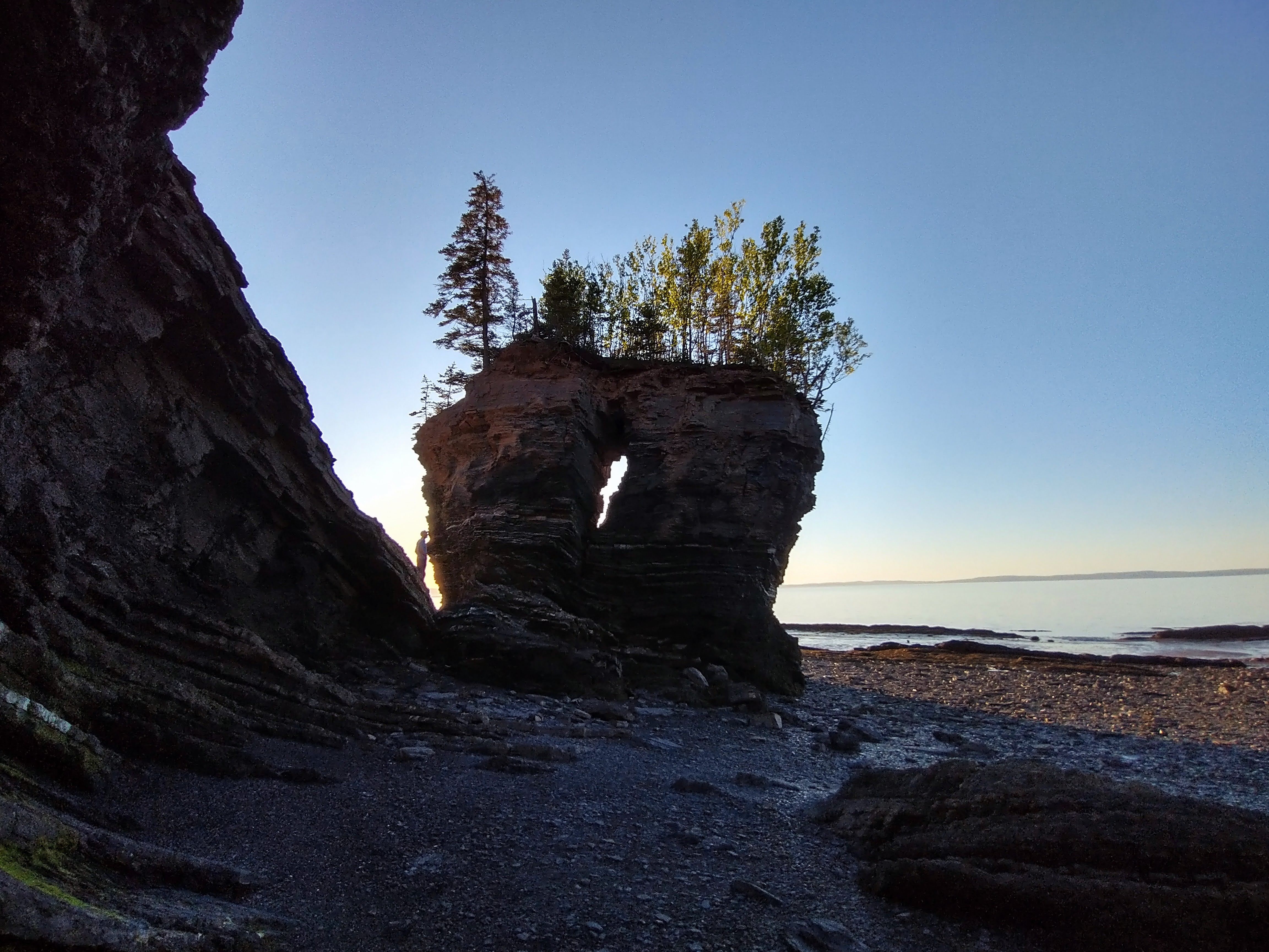
Flower Pot Rock
|
 |
| Bramber Beach |
Once again, Google Maps satellite view, and Google Maps Street View, are your friends to find a suitable launch site. There are several "established" sites, most notable in Inverness @ Broad Cove, and the Mabou cliffs, but often you will just have to find a site that works for that day's wind direction by Map searching.
Back on the mainland, there are a couple of flying sites near the Halifax area. The most commonly flown one is Lawrencetown Beach, with a flying site at the Tea House/Surf Shop, and another flying site a few km's down the road at Half Island. Both sites take a SW, and there is beach to land at. There is another site at Hirtles Beach, near Lunenburg, also takes a SW (SSW is better), just follow the public path up the bluff and find a spot which is not too covered with wild roses to lay out.
 |
| Flying at Half Island near Lawrencetown Beach. |
 |
| Lawrencetown Beach Tea House |
 |
| Half Island. West launch is just outside the FOV on the left, south launch is in the distance. |
 |
| Half Island from the south launch. |
Finally, the most flying in Nova Scotia takes place in the Parrsoboro area. There used to be a school, but is has since shut down, so the flying is now less, but the sites remain! There are various sites for SW, S, SE, and E. And once again, be aware of the Bay of Fundy's tides and the fact the beach LZ may disappear during your flight.
 |
Flying south of Inverness (launch coordinates). The famous golf course is in the distance!
|
In all these scenarios, please be aware that the winds can change quickly, and what was once a nice breeze can go too strong quickly and now you are being blown back etc. Keep an eye on the ocean for increasing whitecaps, catspaws, streaking, and also your instrument to see if your groundspeeds are going down as the wind picks up. And if the temperature is getting too hot, you may get the famous "heat bubble" in which the ground is too hot to allow the ocean wind to come ashore, so you can see the wind just offshore, but it will be calm or not windy on launch. You can wait all day for the wind to get the final km or so, but it will not arrive and tease you all day! So if the day is predicted to very hot, this phenomena has a good possibility of happening.
 |
| One of the many views from the Cabot Trail. |
For a more complete listing of flying sites, go to the HPAAC website. It is updated regularly so the contact numbers listed there will be current.
 |
| Bramber Beach at sunset. |


No comments:
Post a Comment